GIS Fundamentals
Final Project
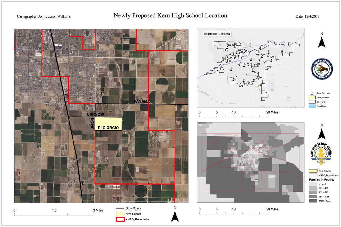
Scenario: The Administrator for Bakersfield’s Kern High School District (KHSD) has the final ‘say’ in where the next high school is built in the City. Her colleagues have all provided their input, but only consulted with their Departments and City Council members whose interests reflect their Wards and maybe not the betterment of the community-at-large. However, the Administrator has decided to take a different approach by trusting her GIS team to find the best answer.
Results: I chose this location for the newly proposed school for a few reasons. First, the proposed location is on the outskirts of town, which will give residents in that area less travel time to school. It will also reduce the amount of traffic congestion already caused by a rapidly growing population. Third, the money being used to build the school will give our new generation of students the most up to date technology, which will allow more hands on learning. Lastly, building the school in this location will bring down student congestion at the other high schools in KHSD. While it also does have cons, such as being further away from the majority of Bakersfield, as well as longer travel times for those who have to commute, overall, I am satisfied with this proposed location for KHSD's newest high school.
Results: I chose this location for the newly proposed school for a few reasons. First, the proposed location is on the outskirts of town, which will give residents in that area less travel time to school. It will also reduce the amount of traffic congestion already caused by a rapidly growing population. Third, the money being used to build the school will give our new generation of students the most up to date technology, which will allow more hands on learning. Lastly, building the school in this location will bring down student congestion at the other high schools in KHSD. While it also does have cons, such as being further away from the majority of Bakersfield, as well as longer travel times for those who have to commute, overall, I am satisfied with this proposed location for KHSD's newest high school.
Introduction to Map Design
Final Project
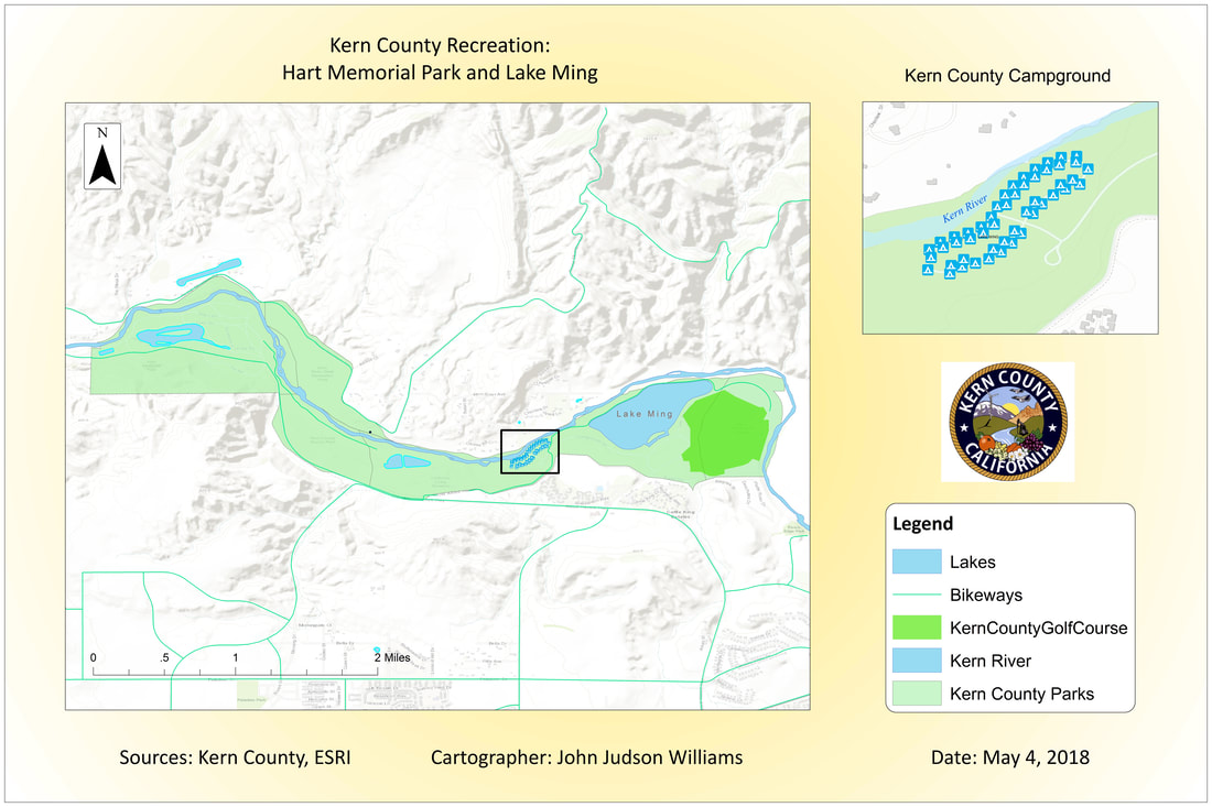
Scenario: You are a GIS Technician for Kern County Parks & Recreation department and have been asked by your boss to work with the planning department to develop a poster to promote the use of the area along the Kern River from Lake Ming (East) to Hart Park (West). Your boss and other planners will be presenting this poster during a televised Board of Supervisors meeting to gain support for increased annual funding. The funding will go to repair, improve and preserve this area for future generations! In general, you should also consider from this scenario what types of questions the Board of Supervisors may ask during the presentation. You will likely attend the meeting in support of your map and boss.
Your goal is to create a map that will promote the Bakersfield lifestyle by displaying multi-use splendor of this area for local residents and visitors alike – you will present activities that make this attractive to families, adventurers, sportsman, schools, athletes, etc. You will be highlighting the recreational and/or leisure activities to show the diverse nature of this outdoor area. The map can also reflect any identified lacking resources or needs of this area that would further sustain this area or promote growth.
Results: The final map that will be presented focuses on leisurely activities such as biking, camping, and hiking. I feel there is not enough focus on these three activities for the public to become more interested, which means less is being done to maintain these areas. When I visited Lake Ming and Hart Park, I noticed the bike paths and hiking trails did not look the greatest. If these areas were better taken care of, more residents and visitors would want to check them out and explore. I believe highlighting this during the Board of Supervisors meeting will help them realize some funding needs to be set aside for trail and bike path maintaince and upgrades, as well as the Kern River Camp Ground. Although I did not visit the camp ground itself, I noticed the area surrounding it could be cleaned up a bit.